

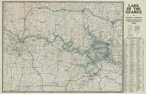
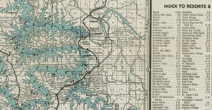
Lake of the Ozarks Original Map dated 1935 Resorts, camps, lodges, clubs and more.
$90.00 USD
Historic 1935 Lake Map by Gallup – A Conversation Piece for Your Lake Home
Decorate your lake home with this interactive historic map, originally created by Gallup Map Company in 1935. More than just wall art, this piece is a rich visual record of lake life from nearly a century ago — featuring camps, resorts, clubs, lodges, beaches, fish hatcheries, marinas, towns, and cabins.
Unlike modern versions, this map extends far west past Warsaw, covering all of Benton County and nearly 40% of present-day Truman Lake, making it a treasure for anyone who wants to explore the lake’s early history.
Why You’ll Love It:
-
Reproduction of an authentic 1935 Gallup lake map
-
Includes landmarks and features no longer on modern maps
-
Perfect for sparking conversations with guests and lake enthusiasts
-
Adds rustic charm and storytelling to any lake home or cabin
-
Printed on high-quality rolled canvas for easy framing or display
If you’re passionate about lake history or simply love the charm of vintage cartography, this map will be the heart of your lake home décor.